Saturday, 20 October 2018

Athirappilly Water Falls


Located 60 km from the Thrissur district of Kerala, Athirapally Falls is a marvellous cascade of frothy waters that makes its way from the Anamudi mountains of the Western Ghats. This 80 ft high and 330 ft wide marvel is situated at the entrance of the Sholayar ranges and is often referred to as the "Niagara Falls of India". From here, the Athirapally falls flows through the verdant greenery of Vazhachal Forest toward the Arabian Sea, creating a spectacular vista of scintillating water, emerald jungles and azure sky. 
When you land in Athirapally, you are greeted with the sight of charming green Sholayar Peaks peering over the rushing gush of the falls. Standing against the backdrop of a rustling jungle foliage, the scenery is as picturesque as it can get. Bird lovers cannot miss this place, for it is the only place in the Western Ghats where four endangered Hornbill species are seen. There is a pool above the falls where you can relax and unwind. To get a view of the waterfall, one needs to get down from the mountain for about 100 meters.

Another interesting fact to note is that the fall joins forces with the Chalakkudy river before reaching its final destination into the sea. Owing to its scenic beauty, it is one of the most popular picnic spots in Kerala. There are a couple of water theme parks on the way to Athirappilly called Silver Storm and Dream World and many resorts as well.

The precarious yet thrilling pathways up to the falls is a treat for mountaineers who are looking for a quick adventure. The trek routes are very well maintained and you get to savour a spectacular view of the falls thoughout. Colourful birds and lots of monkeys will keep you company throughout the way, and if you're lucky some Samba deer might pay you a visit as well! Washrooms are available throughout the way for the convenience of the travellers. There is a path which takes you right to the base of the falls where the view is simply amazing. However, security personnel is deployed there, so be careful when you access this part of the trek. 

Though monsoon season provides the best views, trekking to the falls becomes difficult. The favourable time to visit the Athirapally falls, when you can enjoy both the beauty and the thrill, are from the month of September- January.


Monday, 15 October 2018

Meesapulimala

Meesapulimala is the second highest peak in the Western Ghats of Idukki district (Kerala) on the Indian subcontinent after Anamudi. Its peak is 2,640 metres (8,661 ft) above sea level.The name derives from the fact that it is formed of eight peaks which spread like a "Moustache" and it is located in between the Anaimalai Hills and Palani Hills near Suryanelli around 20km away from MunnarKolukkumalai tea estate, Top Station and Tipadamala (2135m) is also nearby.


The beauty of Meesapulimala has to be enjoyed through trekking. The 8 kilometre long trek from the Rhodovalley, 15 kilometres from Munnar town, offers the trekkers breathtaking views of the grasslands, rainforests and wildlife present at the high altitude. Rhodovalley is named thus due to the red rhododendron trees, which bloom here.

Though the trek is long, it is average. The treks start from the campsite at the base of the first hill. From here it continues on to the mesmerizing forests of the Shola grassland. The trail begins to get a little steep, just about 10 minutes from start. In no time you would be at the peak of the first of the eight hills. From the cloud-kissed mountain tops, you would get a picturesque view of Munnar and Surianelli towns.

A point to be noted is that the beautiful purple Kurinji flower (Neelakurinji), blooms once in every 12 years (the next would be happening in the year 2020). And so plan your trip coinciding with this phenomenon and get a magical view of this from the peaks of Meesapulimala.

Tuesday, 1 November 2016

Kuttanad


It is the major rice granary of Kerala, where vast stretches of verdant paddy fields are interlaced with enchanting backwaters create some of the unforgettable sights.

Kuttanad, the rice bowl of Kerala is all about an agrarian community, striking a chord of harmony with its physical setting. Noted for its farming below sea level (about 4 to 10 feet) the land of Kuttanad possesses a socio-cultural fabric of its own. Four major rivers in Kerala viz. Pampa, Meenachil, Achankovil and Manimala flow into the region.


The best thing for a visitor to Kuttanad is that, one can take deviations from either side of the Alappuzha-Chanaganasserry road to reach villages, predominantly consisting of farmers. During the harvest season the vast expanse of paddy fields, at some places dotted with islets of coconut trees, will be busy with farmers engrossed in different farming activities;done in the traditional manner. Quite early in the morning itself one can sight the women folk heading towards the paddy fields carrying their lunch box and sickle, and on the other hand men could be seen already on the fields till the land, sowing the seeds, getting rid of weeds, diverting water channels etc.


The Kuttanad area is also rich in avian population, and one can easily find flocks of parrots hovering in the paddy fields, especially those fields with rice stalks in bloom. You may also come across a black blanket sweeping across the sky, which on close look will reveal as yet another flock of birds. And this time its is the darter birds, which haunt the backwaters in and around Kuttanadand the adjoining Vembanad Lake.

As you explore the villages, don't forget to take a walk by the numerous canals that criss cross Kuttanad, which are lined by tall coconut trees swaying in the breeze. During most part of the day, these canal stretches would be abuzz with different activities. There will be vendors on boat selling vegetables, grocery and fish to households on the banks of these canals. You would also come across big country boats called Kettu Vallams on which goods like coconut husk, rice grains etc. are transported to nearby markets in bulk. Among the sights on the backwaters here at Kuttanad, the most fascinating obviously is that of the ducks, quacking together in high decibels and moving across the backwaters in large numbers;shepherded by men on small boats. One can also catch men playing on the backwater;some diving down to collect lime shells from the depths and others fishing with their nets and traditional cane basket called Ottal.

For those interested in trying out few local dishes may do so by dropping at the small traditionally built wayside eateries, which are quite famous for backwater fish delicacies and tapioca. A popular naturally extracted beverage is the toddy, which is available in plenty and enjoyed by many for its speciality.

You may also find Kuttanad, a bit more exciting, if you hire a boat. You can hire motorboats, houseboats etc. from the boat jetty operated by the government as well as private groups near the KSRTC Bus Station at Alappuzha or else may get on one from places like Kidangara, which is on the Alappuzha-Changanasserry road. Some of the places worth visiting in the Kuttanad area are Nedumudy, Kaavalam, Champakkulam etc.


Best time to Visit Kuttanad is from September to March,when the region experiences Cool & Pleasant Weather.

Munnar


Munnar is situated at the confluence of three mountain streams - Mudrapuzha, Nallathanni and Kundala. 1,600 m above sea level, this hill station was once the summer resort of the erstwhile British Government in South India. Sprawling tea plantations, picture-book towns, winding lanes and holiday facilities make this a popular resort town. Among the exotic flora found in the forests and grasslands here is the Neelakurinji. This flower which bathes the hills in blue once in every twelve years, will bloom next in 2018. Munnar also has the highest peak in South India, Anamudi, which towers over 2,695 m. Anamudi is an ideal spot for trekking.

Let us now explore some of the options in and around Munnar that would provide travellers ample opportunities to enjoy the captivating hill station of Munnar.

Eravikulam National Park


One of the main attractions near Munnar is the Eravikulam National Park. This park is famous for its endangered inhabitant - the Nilgiri Tahr. Spread over an area of 97 sq. km., this park is also home to several species of rare butterflies, animals and birds. A great place for trekking, the park offers a magnificent view of the tea plantations and also the rolling hills caressed by blankets of mists. The park becomes a hot destination when the hill slopes here get covered in a carpet of blue, resulting from the flowering of Neelakurinji. It is a plant endemic to this part of the Western Ghats which blooms once in twelve years.

Anamudi Peak


Located inside the Eravikulam National Park is the Anamudi Peak. This is the highest peak in south India standing at a height of over 2700 m. Treks to the peak are allowed with permission from the Forest and Wildlife authorities at Eravikulam.

Mattupetty


Another place of interest, located about 13 km from Munnar Town, is Mattupetty. Situated at a height of 1700 m above sea level, Mattupetty is known for its storage masonry dam and the beautiful lake, which offers pleasurable boat rides, enabling one to enjoy the surrounding hills and landscape. Mattupetty's fame is also attributed to the dairy farm run by the Indo-Swiss Livestock Project, where one would come across different high yielding breeds of cows.

Pallivasal


Pallivasal, located at about 3 km from Chithirapuram in Munnar is the venue of the first Hydro-electric project in Kerala. It is a place of immense scenic beauty and is often favoured by visitors as a picnic spot.

Chinnakanal & Anayirangal


Near the town of Munnar is Chinnakanal and the waterfalls here, popularly known as Power House Waterfalls, cascade down a steep rock 2000 m above sea level. The spot is enriched with the scenic view of the Western Ghat ranges. When you have traveled about seven kilometers from Chinnakanal, you reach Anayirangal. Anayirangal, 22 km from Munnar, is a lush green carpet of tea plants. A trip on the splendid reservoir is an unforgettable experience. The Anayirangal dam is surrounded by tea plantations and evergreen forests.

Top Station


Top Station, which is about 32 km from Munnar is at a height of 1700 m above sea level. It is the highest point on the Munnar-Kodaikanal road. Travellers to Munnar make it a point to visit Top Station to enjoy the panoramic view it offers of the neighbouring state of Tamil Nadu. It is one of the spots in Munnar to enjoy the Neelakurinji flowers blooming over a vast area.

Tea Museum


Munnar has a legacy of its own when it comes to the origins and evolution of tea plantations. Taking account of this legacy and to preserve and showcase some of the exquisite and interesting aspects on the genesis and growth of tea plantations in Kerala's high ranges, a museum exclusively for tea was opened some years ago by Tata Tea in Munnar. This Tea Museum houses curios, photographs and machineries; all of which have a story to tell on the origins and growth of tea plantations in Munnar. The museum is located at the Nallathanni Estate of Tata Tea in Munnar and is worth a visit.

Getting there

Nearest railway station: Aluva about 108 km and Angamali, about 109 km
Nearest airport: Cochin International Airport, via Aluva - Munnar Rd, about 108 km.

Monday, 31 October 2016

Ponmudi


Ponmudi (Malayalam: പൊന്മുടി) (the Golden Peak) is a hill station in the Thiruvananthapuram district of Kerala in India. It is located 55.2 km north-east of Trivandrum city at an altitude of 1100 m. It is a part of the Western Ghats mountain range that runs parallel to the Arabian Sea.

Ponmudi is blessed with scenic splendor and natural beauty, Ponmudi has a carpet of thick tropical forest that rolls down to the foot of the hill range. No doubt, the salubrious atmosphere and the twisted trails across clear streams must have contributed to her health.

Ponmudi is connected to Trivandrum by a narrow winding road offering scenic views on the way to Ponmudi. The climate is pleasant year-round. Ponmudi serves as a base for trekking and hiking. There are also tea gardens in the area. There are 22 hairpin turns along this short route which makes the travel a definitely thrilling experience.

Other attractions near Ponmudi include Golden Valley and a number of rivulets and rapids, some even across the road. The lush forest area has tropical vegetation.A variety of wildlife inhabit the hills. The Golden Valley offers vistas of the hills and access to the Kallar River. Flowing though a wilderness area, it has rounded pebbles, cool water, fish, and lush green trees.

Some notable tourist attractions located in Ponmudi are Peppara Wildlife Sanctuary, Echo Point and various trekking spots. Mist-laden valleys, especially Golden Valley near Kallar River, also draw tourists. Travelers can find a deer park and wood and stone cottages coloured in bright hues while visiting here.Located about 1.5 km from the hill station, is the Ponmudi Falls. Around 3 km from the Ponmudi Resort, is the popular Deer Park. The Meenmutty Falls, another popular attraction of the region, is about 3 km from the Kallar Main Road. Peppara Wildlife Sanctuary, located on the outskirts of Ponmudi, is a preserve spread across 53 km and accommodates a variety of wild animals and birds like Asian elephants, sambar, leopards, lion-tailed macaques, Malabar grey hornbills, etc.

Another main attraction in the region is Agasthyarkoodam, one of the highest peaks in the Western Ghats, with the highest peak at 1868 m. This peak is famous for its wilderness, and can be accessed only with the Forest Department's permission. Agasthyarkoodam Biosphere Reserve is another popular attraction covering Neyyar, Peppara, Shendumey Wildlife Sanctuaries and divisions of Achencoil, Thenmala, Konni, Punalur, and Thiruvananthapuram.

Sunday, 23 October 2016

Anamudi


                                   Anamudi or Anai Mudi is a mountain located in the Indian state of Kerala. It is the highest peak in the Western Ghats and South India, at an elevation of 2,695 metres (8,842 ft),and a topographic prominence of 2,479 metres (8,133 ft).The name Anamudi literally translates to "elephant's forehead," a reference to the resemblance of the mountain to an elephant's head.

The first recorded ascent of Anamudi was by General Douglas Hamilton of the Madras Army on May 4, 1862, but it is likely that there had been earlier ascents by local people.

Anamudiis the highest peak in the Western Ghats in India, having an elevation of 2,695 metres (8,842 ft).Anamudi is also the highest point in South India. This gives Anamudi its relatively large topographic prominence of 2,479 metres (8,133 ft), the associated key saddle being over 2,000 kilometres (1,200 mi) away at 28°35′20″N 76°27′59″E in Haryana state just to the west of Delhi. The peak is the highest point of the Periyar river basin.

The peak is not exceptionally dramatic in term of steepness or local relief and is a Fault-block mountain. It is located in the southern region of Eravikulam National Park at the junction of the Cardamom Hills, the Anaimalai Hills and the Palani Hills. The nearest town is Munnar, 13 kilometres (8.1 mi). The easiest route to the summit of Anamudi is a technically easy hike on grass slopes, starting from a rolling hill plateau with a base elevation of about 2,000 metres (6,600 ft). The north and south slopes are gentle, while the east and west slopes are steeper, with more difficult rock faces.

Anamudi and the Eravikulam National Park surrounding it is home to the largest surviving population of the Nilgiri tahr(Nilgiritragus hylocrius). Asian elephants, gaur, Bengal tigers, and the Nilgiri marten (Martes gwatkinsii) are some of the species of animals found here .The Anamudi peak area is also habitat of a unique frog Raorchestes resplendens.This newly discovered species is located in the Eravikulam National Park and is restricted to less than three km2 on the summit of Anamudi. The summit of the Anamudi is vegetated with patches of stunted Arundinaria densifolia and Gaultheria fragrantissima (wintergreen), Anaphalis sp., Impatiens and some species of Eriocaulon.

Monday, 9 March 2015

Kodaikanal

Kodaikanal is a city in the hills of the Dindigul district in the state of Tamil Nadu, India. Its name in the Tamil language means "The Gift of the Forest". Kodaikanal is referred to as the "Princess of Hill stations" and has a long history as a retreat and popular tourist destination.


Kodaikanal was established in 1845 as a refuge from the high temperatures and tropical diseases of the plains..Much of the local economy is based on the hospitality industry serving tourism. As of 2011, the town had a population for 36,501.

The town of Kodaikanal sits on a plateau above the southern escarpment of the upper Palani Hills at 2,133 metres (6,998 ft), between the Parappar and Gundar Valleys. These hills form the eastward spur of the Western Ghats on the Western side of South India. It has an irregular basin as its heartland, the centre of which is now Kodaikanal Lake a 5 kilometres (3.1 mi) circumference manmade lake.
Meadows and grasslands cover the hillsides. Gigantic Eucalyptus trees and shola forests flourish in the valleys. Mighty rocks and cascading streams lie above the valleys. There are many high waterfalls and ubiquitous gardens and flower beds in bloom.

Kodaikanal is known for its rich flora. Of the big trees, cypress, eucalyptus and acacia are the dominant varieties. Pear trees are numerous and the fruits are of high quality. Competing with the fruit trees are the flowering ones - mainly rhododendron and magnolia. Large dahlias of different hues are the main attraction of Bryant Park, situated close to the Kodai lake. Water lilies in the park's pond are another pleasing sight. The town abounds in a kind of beautiful yellow wild flowers.
North of the town, high hills that slope down into the villages of Pallangi and Vilpatti stand guard. On the east the hill slopes less abruptly into the lower Palnis. A precipitous escarpment facing the Cumbum Valley is on the south. On the west is a plateau leading to Manjampatti Valley, Indira Gandhi National Park, the Anamalai Hills and the main body of the Western Ghats.

 Kodaikanal has a monsoon-influenced subtropical highland climate. The temperatures are cool throughout the year due to the high elevation of the city

 Kodaikanal has several scenic natural attractions which are enjoyed by its visitors and make it a popular romantic destination for newlyweds. These are described in order of distance from the bus-stand :-

Kodaikanal Lake, is an artificial, roughly star-shaped 45 ha (60 acres) lake built in 1863. It is recognized as Kodaikanal's most popular geographic landmark and tourist attraction. Rowboats and pedalos can be hired at the Kodaikanal Boat Club. Horses and bicycles can be hired beside the lake for short periods. The 5 kilometres (3.1 mi) path that skirts the periphery of this lovely lake is a favourite walk for the locals and tourists alike.

 Bryant Park: Just east of the lake and 500 metres (1,600 ft) from the bus stand, is a wonderfully maintained 20.5 acres (8.3 ha) botanical garden. The park was planned and built in 1908 by a forest officer from Madurai, H.D.Bryant, and named after him. With 325 species of trees, shrubs and cacti, the park is a rainbow of stunning flowers during the peak season. A large section is dedicated to nearly 740 varieties of roses. There is an 1857 Eucalyptus tree and a Bodhi tree which adds a religious significance to the park. Ornamental plants are cultivated in a nursery for sale. The park organizes horticultural exhibits and flower shows every summer, to coincide with the peak season. The entrance fee to the park is nominal, and it is open all year.

 Silver Cascade, 8 kilometres (5.0 mi) from Kodaikanal at a wide bend in the long and winding Laws Ghat Road, at altitude 1,800 metres (5,900 ft), is a 55-metre (180 ft) waterfall formed from the outflow of Kodaikanal Lake. The water quality is reportedly poor and not good enough for bathing.This impressive waterfall is a popular stop for first-time visitors. There are a few souvenir and fruit vendors and many monkeys here. There is also a smaller but more serene waterfall below the bridge which crosses the stream here.

 Coaker's Walk, 500 metres (1,600 ft) from the bus-stand, constructed by Lt.Coaker in 1872, is a 1-kilometre (3,300 ft) paved pedestrian path running along the edge of steep slopes on the southern side of Kodai. The walk, winding around Mount Nebo, starts in front of the Van Allen hospital, running parallel to the Van Allen Hospital Road and joins the main road beside St.Peter's Church, providing a stunning panoramic view of the plains. On a clear day one can view as far as Dolphin's Nose in the south, the valley of the Pambar River in the southeast, Periyakulam town and even the city of Madurai. A fascinating rare phenomenon called Brocken spectre can be witnessed, when a person can see his shadow on the clouds with a rainbow halo. This occurs when the sun is behind the viewer and clouds and mist are to the front. There is an observatory with a telescope halfway along the walk. Entrance fee to the walkway is nominal and it is open all year.

 Visit Kodai from April to June or August to September. This is when the weather is at it's best - temperatures stay in the region of a comfortable 20°C to a bracing 10°C.


Saturday, 19 April 2014

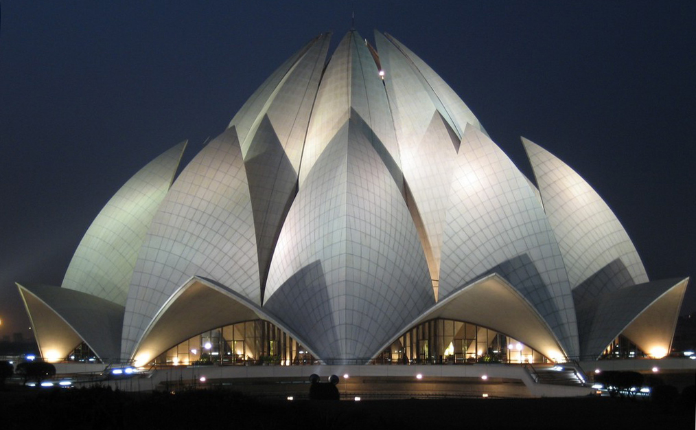
Lotus Temple

The Lotus Temple, located in New DelhiIndia, is a Bahá'í House of Worship completed in 1986. Notable for its flowerlike shape, it serves as the Mother Temple of the Indian subcontinent and has become a prominent attraction in the city. The Lotus Temple has won numerous architectural awards and been featured in hundreds of newspaper and magazine articles.

Like all other Bahá'í Houses of Worship, the Lotus Temple is open to all regardless of religion, or any other distinction, as emphasized in Bahá'í texts. The Bahá'í laws emphasize that the spirit of the House of Worship be that it is a gathering place where people of all religions may worship God without denominational restrictions.The Bahá'í laws also stipulate that only the holy scriptures of the Bahá'í Faith and other religions can be read or chanted inside in any language; while readings and prayers can be set to music by choirs, no musical instruments can be played inside. Furthermore no sermons can be delivered, and there can be no ritualistic ceremonies practiced.

All Bahá'í Houses of Worship, including the Lotus Temple, share certain architectural elements, some of which are specified by Bahá'í scripture. `Abdu'l-Bahá, the son of the founder of the religion, stipulated that an essential architectural character of a House of Worship is a nine-sided circular shape. While all current Bahá'í Houses of Worship have a dome, this is not regarded as an essential part of their architecture. Bahá'í scripture also states that no pictures, statues or images be displayed within the House of Worship and no pulpits or altars be incorporated as an architectural feature (readers may stand behind simple portable lecture stands).The site is in the village of Bahapur, in the National Capital Territory of Delhi. The architect was an Iranian, who now lives in Canada, named Fariborz Sahba. He was approached in 1976 to design it and later oversaw its construction. The structural design was undertaken by the UK firm Flint and Neill. The major part of the funds needed to buy this land was donated by Ardishír Rustampúr of Hyderabad, Sindh, who gave his entire life savings for this purpose in 1953. A portion of construction budget was saved and used to build a greenhouse to study indigenous plants and flowers that would be appropriate for use on the site.[9]Inspired by the lotus flower, the design for the House of Worship in New Delhi is composed of 27 free-standing marble clad "petals" arranged in clusters of three to form nine sides. The nine doors of the Lotus Temple open onto a central hall slightly more than 40 meters tall that is capable of holding up to 2,500 people. The surface of the House of Worship is made of white marble from Penteli mountain in Greece, the very same from which many ancient monuments and other Bahá'í Houses of Worship are built. Along with its nine surrounding ponds and the gardens, the Lotus Temple property comprises 26 acres (105,000 m²; 10.5 ha).
Since its inauguration to public worship in December 1986, the Bahá'í House of Worship in Delhi has, as of late 2002, attracted more than 50 million visitors, making it one of the most visited buildings in the world. Its numbers of visitors during those years surpassed those of the Eiffel Tower and the Taj Mahal. On Hindu celebrative days and holy days, it has drawn as many as 150,000 people in one day.
This House of Worship is generally referred to as the "Lotus Temple". In India, during the  festival Durga Puja, several times a replica of the Lotus Temple has been made as apandal, a temporary structure set up to venerate the goddess Durga. In Sikkim a permanent replica is of the Hindu Legship Mandir, dedicated to Shiva.

Thursday, 17 April 2014

Kumarakom

Kumarakom is a popular tourism destination located near the city of Kottayam (16 kilometres (10 mi)), in KeralaIndia, famous for its backwater tourism. It is set in the backdrop of the Vembanad Lake which is the largest freshwater lake in the state of Kerala.

Kumarakom is home to a wide variety of flora and faunaKumarakom Bird Sanctuary is a noted bird sanctuary where many species of migratory birds visit. The Vembanad Lake, the largest backwater in Kerala, is habitat for many marine and freshwater fish species and it teems with Karimeen (Pearl spot also known as Etroplus suratensis) shrimp (Metapenaeus dobsonii) common name Poovalan chemeen. The bird sanctuary extends over 14 acres (57,000 m²), and came into existence following preservation efforts from the government. It is a very beautiful place to live. It is a major tourist attraction.

Kumarakom has a moderate climate throughout the year. It is a balanced tropical climate, which has two monsoons south west and north east. The average rainfall is 1100 mm .Fishing is mainly done using the small boats (vallams) and gill nets (gear). The main catches are black clam (Villorita cyprinoides),Karimeen (Pearl spot also known as Etroplus suratensis ) and shrimp (Metapenaeus dobsonii).

Kumarakom has a wide variety of houseboats and is well known throughout the world for houseboat experience. They are used only for tourists these days. A separate boat known as Kettuvallam is used by the people to go fishing or to transport goods. Apart from these, there are elegant special boats like Kochu-odi Vallam, Odi-Vallam, Iruttukutthi Vallam, Churulan Vallam and Chundan Vallam(Snake Boat), which take part in the boat races around Onam time.

Tourism in Kumarakom largely revolves -around the backwaters of the Vembanad Lake. Several luxury and budget resorts lined up on the shores of the lake provide tourists with facilities for boating, yachting and fishing, with panoramic views of the lake. The other major attraction is the Bird Sanctuary which can be visited by canoes arranged by local fishermen at the entrance to the sanctuary.Best time to visit sanctuary is morning and evening. A two-hour rowing canoe trip is quite cheap, and is best undertaken in the evening or early morning to avoid the afternoon sun. 

Wednesday, 16 April 2014

Kuttanad - Rice Bowl of Kerala

It is the major rice granary of Kerala, where vast stretches of verdant paddy fields are interlaced with enchanting backwaters create some of the unforgettable sights.
Kuttanad, the rice bowl of Kerala is all about an agrarian community, striking a chord of harmony with its physical setting. Noted for its farming below sea level (about 4 to 10 feet) the land of Kuttanad possesses a socio-cultural fabric of its own. Four major rivers in Kerala viz. Pampa, Meenachil, Achankovil and Manimala flow into the region.

The best thing for a visitor to Kuttanad is that, one can take deviations from either side of the Alappuzha-Chanaganasserry road to reach villages, predominantly consisting of farmers. During the harvest season the vast expanse of paddy fields, at some places dotted with islets of coconut trees, will be busy with farmers engrossed in different farming activities;done in the traditional manner. Quite early in the morning itself one can sight the women folk heading towards the paddy fields carrying their lunch box and sickle, and on the other hand men could be seen already on the fields till the land, sowing the seeds, getting rid of weeds, diverting water channels etc.

The Kuttanad area is also rich in avian population, and one can easily find flocks of parrots hovering in the paddy fields, especially those fields with rice stalks in bloom. You may also come across a black blanket sweeping across the sky, which on close look will reveal as yet another flock of birds. And this time its is the darter birds, which haunt the backwaters in and around Kuttanadand the adjoining Vembanad Lake.
As you explore the villages, don't forget to take a walk by the numerous canals that criss cross Kuttanad, which are lined by tall coconut trees swaying in the breeze. During most part of the day, these canal stretches would be abuzz with different activities. There will be vendors on boat selling vegetables, grocery and fish to households on the banks of these canals. You would also come across big country boats called Kettu Vallams on which goods like coconut husk, rice grains etc. are transported to nearby markets in bulk. Among the sights on the backwaters here at Kuttanad, the most fascinating obviously is that of the ducks, quacking together in high decibels and moving across the backwaters in large numbers;shepherded by men on small boats. One can also catch men playing on the backwater;some diving down to collect lime shells from the depths and others fishing with their nets and traditional cane basket called Ottal.
For those interested in trying out few local dishes may do so by dropping at the small traditionally built wayside eateries, which are quite famous for backwater fish delicacies and tapioca. A popular naturally extracted beverage is the toddy, which is available in plenty and enjoyed by many for its speciality.
You may also find Kuttanad, a bit more exciting, if you hire a boat. You can hire motorboats, houseboats etc. from the boat jetty operated by the government as well as private groups near the KSRTC Bus Station at Alappuzha or else may get on one from places like Kidangara, which is on the Alappuzha-Changanasserry road. Some of the places worth visiting in the Kuttanad area are Nedumudy, Kaavalam, Champakkulam etc.

Best time to Visit Kuttanad is from September to March,when the region experiences Cool & Pleasant Weather.

Tuesday, 15 April 2014

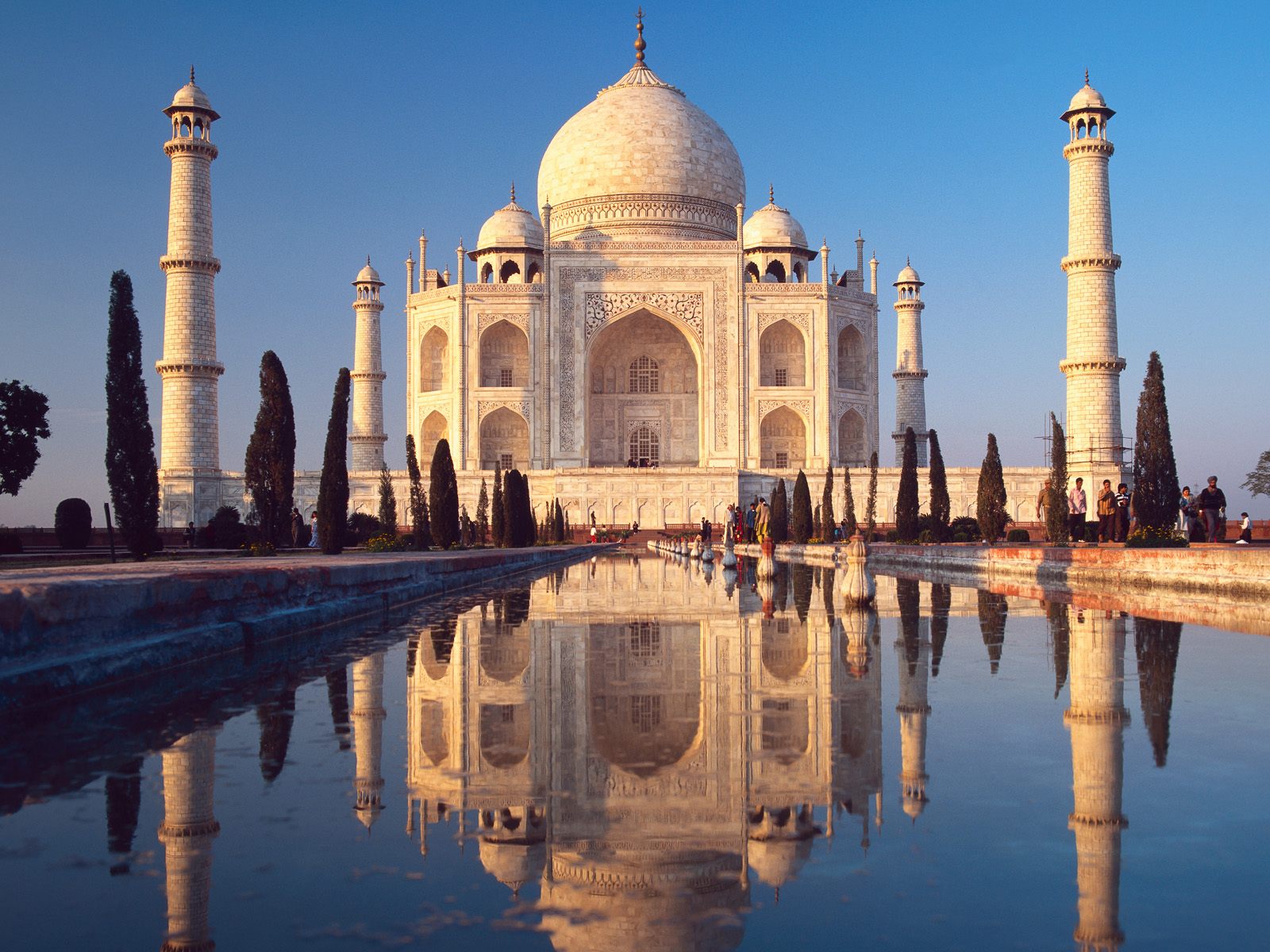
Taj Mahal

The Taj Mahal known as "crown of palaces", is a white marble mausoleum located in AgraUttar PradeshIndia. It was built by Mughal emperor Shah Jahan in memory of his third wife, Mumtaz Mahal. The Taj Mahal is widely recognized as "the jewel of Muslim art in India and one of the universally admired masterpieces of the world's heritage".
Taj Mahal is regarded by many as the finest example of Mughal architecture, a style that combines elements from IslamicPersian,Ottoman Turkish and Indian architectural styles.
In 1983, the Taj Mahal became a UNESCO World Heritage Site. While the white domed marble mausoleum is the most familiar component of the Taj Mahal, it is actually an integrated complex of structures. The construction began around 1632 and was completed around 1653, employing thousands of artisans and craftsmen. The construction of the Taj Mahal was entrusted to a board of architects under imperial supervision, including Abd ul-Karim Ma'mur Khan, Makramat Khan, and Ustad Ahmad Lahauri. Lahauri is generally considered to be the principal designer.
The Taj Mahal incorporates and expands on design traditions of Persian architecture and earlier Mughal architecture. Specific inspiration came from successful Timurid and Mughal buildings including; the Gur-e Amir . Humayun's TombItmad-Ud-Daulah's Tomb , and Shah Jahan's own Jama Masjid in Delhi. While earlier Mughal buildings were primarily constructed of redsandstone, Shah Jahan promoted the use of white marble inlaid with semi-precious stones, and buildings under his patronage reached new levels of refinement.
Night View of Taj Mahal
The Taj Mahal attracts a large number of tourists. UNESCO documented more than 2 million visitors in 2001, including more than 200,000 from overseas. Most tourists visit in the cooler months of October, November and February.

Monday, 14 April 2014

Athirappilly Water Falls

Athirappilly Falls is situated in Athirappilly panchayath in Thrissur district of Kerala, on the southwest coast of India. Located on the west-flowing Chalakudy River near the Vazhachal Forest Division and the Sholayar ranges, this 24-metre (80 ft) waterfall and the nearby Vazhachal Falls are popular tourist destinations. It is nicknamed "The Niagara of India". 

Forest wildlife in the area includes the Asiatic elephanttigerleopardbisonsambar, and lion-tailed macaque. The unique 180 metres (590 ft) elevation riparian forest in the Athirappilly-Vazhachal area is the only location where all four South Indian species of hornbills — theGreat Hornbill (the State Bird of Kerala), Malabar Pied HornbillMalabar Grey Hornbill, and the Indian Grey Hornbill are found living together.

The journey from Chalakudy to the Athirappilly Falls passes through a landscape of winding roads, small villages and lush green trees. Visitors can reach the top of the waterfall via a paved path that leads through thick bamboo clusters. A steep narrow path also leads to the bottom of the falls. The falls attract visitors from across India, especially during the monsoon months (June–September). About 7 million tourists visit the falls and the Vazhachal picnic spot each year.

I think ,best time to visit is just after monsoon... :)

Sunday, 13 April 2014

Kovalam Beach

Kovalam is a beach town by the Arabian Sea in Thiruvananthapuram city, KeralaIndia, located around 16 km from the city center. Kovalam means a grove of coconut trees and true to its name the village offers an endless sight of coconut trees. It is also known as the paradise of the south.
Kovalam has three beaches separated by rocky outcroppings in its 17 km coastline, the three together form the famous crescent of the Kovalam beach
  • Lighthouse Beach
The southernmost beach, the Lighthouse Beach is the one most frequented by tourists, Lighthouse Beach got its name due to the old Vizhinjam Lighthouse located on a rocky promontory here. Its intermittent beams at night render the beach with an unearthly charm.
  • Hawah Beach
Eve’s Beach, more commonly known as Hawa Beach, ranks second, in the early day, is a beehive of activities with fishermen setting out for sea. With a high rock promontory and a calm bay of blue waters, this beach paradise creates a unique aquarelle on moonlit nights.
  • Samudra Beach
A large promontory separates this part from the southern side. Samudra Beach doesn't have tourists thronging there or hectic business. The local fishermen ply their trade on this part.

There are a large number of beach resorts in and around Kovalam. The sea port of Vizhinjam is about 3 km away and famous for its special varieties of fish, old Hindu temples, big churches and a mosque. The Proposed International Trans shipment Terminal at Vizhinjam is also close to Kovalam. Kovalam was among the most prominent tourist spots in India during the hippy era.

The leisure options at this beach are plenty and diverse. Sunbathing, swimming, herbal body toning massages, special cultural programmes and catamaran cruising are some of them. The tropical sun acts so fast that one can see the faint blush of coppery tan on the skin in a matter of minutes. Life on the beach begins late in the day and carries on well into the night. The beach complex includes a string of budget cottages, Ayurvedic health resorts, convention facilities, shopping zones, swimming pools, Yoga and Ayurvedic massage centres.

Visit Kovalam beach from September till March.